
No casualties were immediately reported.
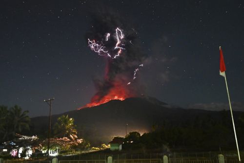
Another eruption on Friday evening had sent clouds of ash up to 10 kilometres high and had lit up the night sky with glowing lava and bolts of lightning.
The two eruptions happened in a span of less than five hours.
Indonesia’s Geology Agency recorded an avalanche of searing gas clouds mixed with rocks and lava traveling up to 5 kilometres down the slopes of the mountain.
Drone observations showed deep movement of magma, setting off tremors that registered on seismic monitors.
Volcanic material, including hot thumb-sized gravel, was thrown up to 8 kilometres from the crater, covering nearby villages and towns with thick volcanic residue, the agency said. It asked residents to be vigilant about heavy rainfall that could trigger lava flows in rivers originating from the volcano.
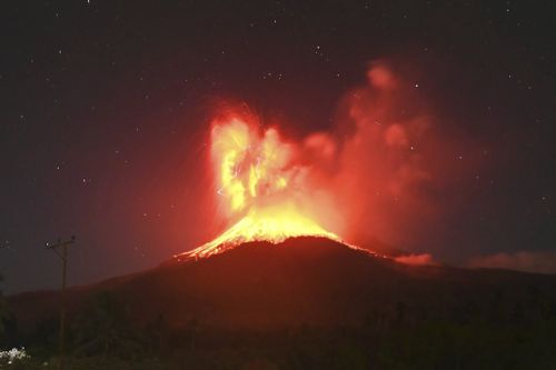
Saturday’s eruption was one of Indonesia’s largest since 2010 when Mount Merapi, the country’s most volatile volcano, erupted on the densely populated island of Java. That eruption killed more than 350 people and forced hundreds of thousands to evacuate.
It also came less than a month after a major eruption on July 7 forced the delay or cancellation of dozens of flights at Bali’s Ngurah Rai airport, and covered roads and rice fields with thick, gray mud and rocks.
Lewotobi Laki Laki, a 1584-metre volcano on the remote island of Flores, has been at the highest alert level since it erupted on June 18, and an exclusion zone has been doubled to a 7-kilometre radius as eruptions became more frequent.
The Indonesian government has permanently relocated thousands of residents after a series of eruptions there killed nine people and destroyed thousands of homes in November.
Indonesia is an archipelago of more than 280 million people with frequent seismic activity.
It has 120 active volcanoes and sits along the “Ring of Fire”, a horseshoe-shaped series of seismic fault lines encircling the Pacific Basin.