
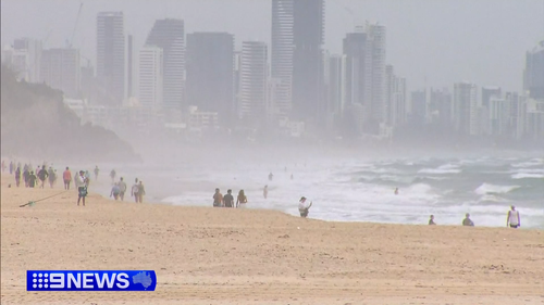
A cool change is beginning to sweep through south-east Queensland after a week of wild weather.
“We’ll see a south-easterly change push through south-eastern Queensland later tonight and into early Saturday. That’ll cool temperatures down by about 5-7 degrees,” the Bureau of Meteorology’s Pieter Claassen said.
While the clouds took the sting out of today, it also means less solar energy in the network, putting more pressure on the electricity grid.
A new peak for electricity use could be reached tonight.
The cool change follows destructive storms while the south-east sweltered through a heatwave.
Temperatures today peaked at 34 degrees on the Gold Coast and 36 degrees in Brisbane.
Queensland’s first cyclone for the year could also be brewing as meteorologists watch a developing low in the far north.
“We do see the potential for a tropical low to form somewhere in the Coral Sea, and potentially the risk of that low developing later in the week does increase,” Claassen said.
If it develops, the cyclone would be named Taliah.
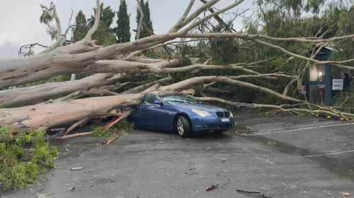
On the Southern Gold Coast crews are still mopping up after yesterday’s wild deluge.
Winds exceeding 90km/h blew away entire market stalls at Coolangatta.
The winds brought down trees and toppled scaffolding while more than 14,000 homes and businesses lost power.
The Bureau of Meteorology warns isolated thunderstorms could develop again today.
Much of the country will experience warm days and nights into the weekend.
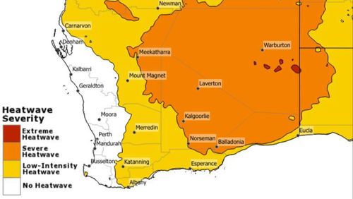
Western Australia will also experience severe to extreme heatwave conditions today, particularly across the Central Wheat Belt, Great Southern, Goldfields and South Interior districts.
A severe storm also ripped through the Pilbara yesterday evening with wind gusts above 100km/h.