
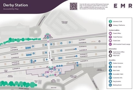
East Midlands Railway has introduced an enhanced set of Accessibility Maps that are designed to improve station navigation for passengers with additional mobility requirements. These detailed guides provide comprehensive information about accessible facilities across key stations, including Chesterfield, Derby, Leicester, Sheffield, and London St Pancras, along with the Robin Hood Line route.
The Accessibility Maps were developed in collaboration with East Midlands Railway’s Accessibility Panel, which is comprised of disabled travelers who provided firsthand insights. The resources highlight crucial features such as step-free access, elevator locations, accessible restrooms, and boarding assistance points.
The Accessibility Maps are available through multiple channels, including digital downloads, station displays, and customer service requests. The initiative will serve to empower passengers with reliable pre-journey planning tools and on-site navigation aids.
Image Credit: East Midlands Railway