
Townsville has received almost an entire year’s worth of rain in just over a week.
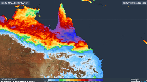
The flood-hit area was hit with its highest February rainfall total- 1033mm – in just the first week of this month.
As the clean-up from the record-breaking rain continues across North Queensland locals are getting in while they can, while being warned more could be on the way.

Major flood warnings remain in effect for several catchments and rivers, with one river likely to reach major levels, potentially cutting off the Bruce Highway, near Ayr.
Meanwhile in the rural town of Ingham, near Townsville, the scale of destruction is becoming clear.
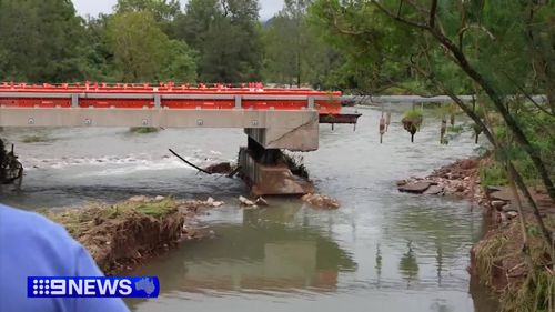
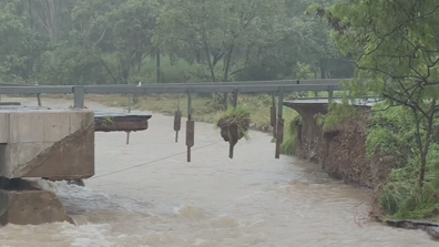
A temporary bridge had to be built by the ADF after the community was inundated with water.
Streets are lined with stacks of what folks here couldn’t save, from water-logged whitegoods to muddied mattresses.
Cleaning up is a slow and harrowing task.
While supplies are being flown in, to get freight to far flung communities cut off by flood water is a bigger challenge.
West of Ingham near Greenvale there’s a b-double graveyard of trucks, which are stuck in limbo waiting for water to go down.
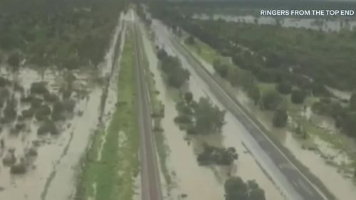
Hundreds of roads across the north remain cut off.
Heading west from Charters Towers is impossible if you don’t have a chopper.
Driving east there’s not a chance.
The temporary bridge at Ollera Creek shut overnight, before the build of a permanent more durable bridge gets underway.
While there’s been a brief pause in the downpours, North Queenslanders’ real chance to dry out could be days away.
Senior Meteorologist Miriam Bradbury warned there was no relief in sight for parts of the state, as extensive rain and storms were forecast into Monday.
Herbert River, Haughton River, Cape River, Upper Burdekin and Lower Burdekin Rivers and Flinders River are facing major flooding.
The Cape River at Taemas is currently at 8.76m and continues to rise.
A severe weather warning remains in place for the North Tropical Coast and Tablelands, as well as the Herbert and Lower Burdekin forecast districts.
ADF to build temporary bridge to give access to flood-ravaged town
Heavy rainfall is expected between Tully and Ayr into the early part of the week.
“Heavy rainfall which may to dangerous and life-threatening flash flooding is forecast for parts of the Herbert and Lower Burdekin and the North Tropical Coast this weekend,” Bureau of Meteorology said.
“The six-hourly rainfall totals between 120 to 180 mm are possible. Isolated 24-hourly rainfall totals up to 250mm are possible.
“Conditions are expected to temporarily ease from early this morning, with the potential for isolated heavy falls to return by this evening or early Monday morning.
“Heavy rainfall increases the potential for landslides and debris across roads.”
The heaviest rainfall totals recorded include 274mm at Halifax, 236mm at Gairloch and 150mm at Ingham.
State prepares for possible tropical cyclone
Communities in Western Australia remain on watch for a possible tropical cyclone, according to Bradbury.
“Tropical low 18U is not yet a tropical cyclone but may strengthen to tropical cyclone intensity in the next 24 hours. If and when it reaches tropical cyclone strength, the system would be called Tropical Cyclone Zelia,” she said.
The tropical low is currently located near the Kimberley coast, with communities between Cockatoo Island, Bidjuanga and Broome all under a cyclone watch.
“In this watch area, we may see gales developing as early as Monday morning,” Bradbury said.
“We’re also likely to see rain increasing as well, likely from later on (today), with large waves also a risk as winds increase.”
The tropical low could reach tropical cyclone intensity later today or tomorrow.